Maps and views blog

Cartographic perspectives from our Map Librarians

Introduction

Our earliest map appears on a coin made in the Roman Empire and our latest appears as pixels on a computer screen. In between we have the most complete set of Ordnance Survey maps of Great Britain, the grand collection of an 18th-century king, secret maps made by the Soviet army as well as the British government, and a book that stands taller than the average person. Read more

13 September 2016

The long search for HMS 'Terror'

45 B20175-13 (1)

Above: the Northwest Passage as charted by Capt. Robert McClure. Chart shewing the Northwest Passage discovered by Capt. Robert le M. M’Clure [Maps.982 (51)].

Yesterday The Guardian broke the news that, after over 160 years of searching for the ships commanded by Sir John Franklin on his doomed expedition, HMS Terror had been found in the Arctic. Submerged in Terror Bay, part of King William Island, the ship is in remarkably good condition and promises, like HMS Erebus, found in 2014, to provide further details as to what happened to Franklin and his crew in their final days. What the find achieves straight away is to provide an end to the search for these two ships, an endeavour which, during the nineteenth, twentieth and twenty-first centuries, has become a story all of its own.

36 T00043-52 HRAbove: the men of HMS Resolute entertain themselves with a winter ball and on-ship theatre, from The Illustrated Arctic News [BL: 1875.c.19]. 

The search for HMS Erebus and Terror and the various stories, published accounts and maps which arose from this endeavour have become their own drama filled with shocking discoveries, perils and intrigues which have captivated imaginations across the world. This is the focus of the middle part of the upcoming book, Lines in the Ice: Exploring the Roof of the World, which predominantly uses the British Library's collections to shed light on the long history of this search. Sir John Franklin and those who travelled with him disappeared in the Canadian Arctic while searching for something that had obsessed mariners from England and Scotland for centuries, an Arctic trade route via the 'Northwest Passage'. During the resulting quest to find Franklin and his expedition many other crews wintered in the Arctic, men found ways to entertain themselves against both hardship and boredom, ingenious tools were used to search new areas and the Northwest Passage itself was crossed; albeit not in the way intended by those hoping to find a trade route in these Arctic waters. The maps and images displayed here are some of those produced in official and published accounts which arose from these expeditions and are reproduced in Lines in the Ice.


44 T00043-72 HR (2)

Above: ships involved in the Franklin searches wait for dawn and the end of winter. 'HMS Assistance and Pioneer in Winter Quarters' [Shelfmark: 1781.a.23].

Eventually these expeditions began to discover what happened to Franklin's crew, even if the ships themselves were not located, and the answers found were not to everyone's taste. During an overland search for the crews of HMS Erebus and Terror Dr. John Rae had encountered Inuit who told him that others in the area had tried to help white men who were heading south. These men, sick and close to death, and the camps they left showed signs that they had resorted to cannibalism to stay alive, something Dr. Rae reported on his return to England. This was met with indignation from many, not least Lady Jane Franklin and those she encouraged to write against Dr. Rae, notably the author Charles Dickens. Despite the rhetoric deployed against Rae and his Inuit informants their account has been shown to be correct by further investigation. However, to this day Inuit accounts of the fate of the expedition and the location of the ships have been treated with distrust by many. How fitting, then, that both ships have now been found in locations which Inuit histories long suggested searchers should investigate.

49 B20174-83

Above: the 'Boat-Cloak', praised by Dr. Rae as an essential tool for Arctic exploration. From Peter Halkett’s published description, Boat-Cloak or Cloak-Boat [1269.d.5].

Lines in the Ice is published by British Library Publishing (UK) and McGill-Queen's University Press (North America) and out now. As the book shows, the search for Franklin is well documented in maps, views and printed books around the world, the end of the story about the fate of the man and his crew, it now seems, will be found beneath the sea.

[PJH] 

09 September 2016

Map exhibition - the countdown begins

The appearance this morning of a vast new wall hanging in the British Library announced to everyone that the next big exhibition is on its way. Shakespeare has barded it up in St. Pancras for the past few months, but it will shortly be the turn of maps. 

Cr5oGLtVYAEvdK3

Maps and the 20th Century: Drawing the Line will tell the story of how maps shaped the world during those tumultuous 100 years. The colossal global hemisphere of our exhibition poster is taken from a World War II American propaganda poster which is centered upon Berlin. It is a massive, beautiful, terrifying image which pretty much sums up what the 20th century is about. 

Another blockbuster map appeared in a story announcing the exhibition in the Evening Standard today. Come and see the great Harry Beck's London tube sketch in November. 

Over the coming days and weeks we'll be introducing a whole lot more of maps to you, ahead of the exhibition opening on 4 November. Share your map likes and stories with us using the hashtag #BLMaps, and follow us on @Britishlibrary and @BLMaps. 

Pre-book your tickets for the exhibition here!

Tom Harper


10 August 2016

Hooked on Georeferencing

Georeference NY

Above: a map of Manhattan from the US subset.

A funny thing happened last week as I noticed that the Georeferencer project's current phase had stalled around the 32% mark. Having checked on the project progress bar for a few days I decided we had lost momentum on the project, perhaps due to it being the summer holidays, personal commitments, a frustration with some of the content, or any other number of other reasons. Deciding I could not encourage more use without 'practicing what you preach' and getting stuck into the current cache of maps, I sat down in my breaks - for the first time in too long - to work through a chunk of the project using the lists of maps 'to be georeferenced' held on Wikimedia Commons.

After working my way through a number of maps I noticed two things. First off, progress on the Georeferencer project has not stalled, instead the counter on the front page has mysteriously stopped working (if you go there now you will still see it needs fixing). Instead, if you go to the 'Participants' tab you will see a different picture, one that suggests that, far from stalling, the project is actually charging along. At the time of writing 24,508 maps have been georeferenced, around 42% of what is currently in the system. The second thing I noticed was that I was hooked. Again.

Pandora voyage

Above: the route of the Pandora, from the Arctic subset.

Yes, despite the fact that there is no emergency or need to inspire more work on the system I'm still finding spare time to do 'just one more', the cartographic equivalent of computer gaming's 'One More Turn' syndrome. Now that I'm hooked I thought I would share some maps I georeferenced that worked out particularly well; the New York one lines up very pleasingly (grid systems make georeferencing much easier) while the map of the voyage of the Pandora satisfies my enthusiasm for Arctic maps, but, as usual, I have enjoyed working on every map I've done in this batch. I should probably back off a little now - not least as I have to sit down and write some talks around my new book - but I suspect I'll be dropping back in for 'Just One More Map' on a regular basis.

Thanks go out, as always, to our volunteers who are working through this large volume of material. We are making great progress here at the Library adding the data produced to catalogue records for the sheet charts, atlases and printed books that contain these maps and each newly georeferenced map means more useful data can be added to the catalogue. For those of you working on the project, don't forget about our lists of maps to be georeferenced over at Wiki Commons, they really do make the project more enjoyable - as I suggested in a previous post. For anyone reading this who wants to get involved in the project for the first time you can find out how here.

[PJH]

03 August 2016

Magnificent Manuscripts Online: Pelagios

Portolano (Egerton MS 2855, f.8r).jpeg

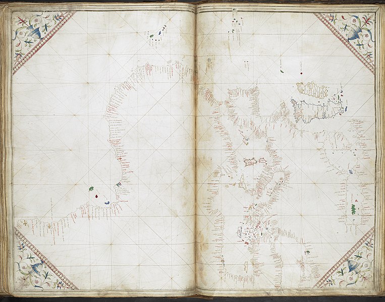
Above: Portolan chart of the North-West coast of Europe, including all of France, the British Isles and Ireland, Grazioso Benincasa [1473, Egerton MS 2855, f.8r]. File at Wiki Commons.

Over the past few years the British Library has been working with the Pelagios project, making innovative use of historic manuscript maps. Meaning ‘of the sea’ the name Pelagios is used as the seas were the highways of the ancient world, much like the Web provides a highway for communication today. A web-based project that facilitates the online linking of data about ancients sites mentioned, for example, in texts, local histories or where archaeological remains have been found. The current phase of Pelagios (in which the Library was involved) will soon be drawing to a close as the next phase, 'Pelagios Commons', begins and runs to December 2017. The Library has contributed digitised materials to phase 3 of this project, predominantly in the form of mappae mundi, itineraries and portolan charts, and these have been digitally annotated to open up the enclosed geographical information to the Pelagios database.

Insularium Illustratum (Additional MS 15760, f.53v).jpeg

Above: A map of England, Northern France, Scotland and Wales from Insularium Illustratum, Henricus Martellus Germanus [1495, Additional MS 15760, f.53v]. File at Wiki Commons.

As you can see, the material provided to Pelagios is something of a treasure trove of manuscript views of the world and the project as a whole is composed of various wonderful resources detailed at Pelagios Commons. Now that our involvement with phase 3 of the Pelagios project is drawing to a close the Library is making the material it contributed to the project available on Wikimedia Commons and (soon) via data.bl.uk. The main root for material held on Commons can be found on the British Library Map Collections category page on Wikimedia Commons, which provides links to the various groups of British Library manuscript materials used in the Pelagios project (although I should note this is a general collections page - so you will not find Ordnance Survey Drawings in Pelagios!). 

File:General chart of the coasts of Europe, the Black Sea, the Mediterranean, and the western coast of Africa south to Cape Negro.- Cornaro Atlas (Egerton MS 73, f.36r).jpeg

Above: General chart of the coasts of Europe, the Black Sea, the Mediterranean, and the western coast of Africa, Cornaro Atlas [1492, Egerton MS 73, f.36r]. File at Wiki Commons.

One health warning about these manuscripts, due to UK copyright law they are technically in copyright until 2039. However, given the age of the manuscripts and their place of production the Library believes it highly unlikely a public domain release will offend anyone; more information can be found here. Copyright notices aside, this is a fantastic resource which we hope you enjoy. If you do dive make sure you clear your diary and sit down with some food to see you through, it's a fascinating collection of material. If you want to know more about Pelagios generally - and perhaps join in - head over to their Commons site. Here you can access online resources that are being developed (using open data methods) to link and explore historical place, as well as participate in various community forums. You can also find more at the Digital Classicist Wiki.  

[PJH]

21 June 2016

War Office Archive goes live in Nairobi

   I_Hub

Nicholas Dykes with John Paul Karijo, Community Manager at i-Hub

In 2014 the British Library received funding from the Indigo Trust to catalogue, conserve and digitise almost 600 colonial-era military intelligence maps of the former British East Africa, part of a rich historical resource held at the library in the so-called War Office Archive. The project was completed last year with a modest underspend, which was put towards promotion and marketing of the project in East Africa itself. As the cataloguer and co-ordinator of the project, I recently travelled to Nairobi to give demonstrations of the new online resource and to deliver talks about the archive’s rich potential for environmentalists and for researchers of African, colonial and personal history.

I spoke first at the British Institute in Eastern Africa, where the talk was recorded. The maps’ potential for use in academic study was well received by the audience. Joost Fontein, Director of the Institute, expressed an interest in discovering what the archive can teach us about the nature of colonial administration, and the role of mapping within it. Philip Winter, Director of the Rift Valley Institute, was keen to learn what the archive reveals of the history behind East Africa’s international boundaries, and how the archive might inform debate around this controversial subject today. And one doctoral student, who has located the temporary settlements of nomadic tribes from tell-tale patterns of vegetation growth seen on aerial photographs and maps from the 1960’s, was keen to use the War Office maps as a new source of data relating to an earlier period.

  WOMAT.AFR.BEA.54

Detail of shelfmark WOMAT/AFR/BEA/54

In the afternoon I travelled across town to i-Hub and a well-attended event there called PizzaFriday. i-Hub is an innovative and youthful space where Nairobi’s tech community meet to work together and share ideas. Current members’ ages range from 17 to 34. I was welcomed by Community Manager John Paul Karijo, whose work has included founding a not-for-profit startup that simplifies the process of enrolment in Kenyan graduate schools to an app on a mobile phone, bypassing the bureaucratic burden of paper forms and official stamps. I also met Jessica Musila, Executive Director of ‘Mzalendo, Eye on Kenyan Parliament’, a website that provides statistics and data relating to political transparency in Kenya, and Douglas Namale, a founder member of Map Kibera, a community mapping project in one of Nairobi’s notorious slum districts. Another young coder told me about his car-share app, which he hopes will help to reduce Nairobi’s chronic traffic congestion.

The community at i-Hub believed that the archive held great potential for local use and development - thoughts included integration of the maps into a historical storytelling platform, to include historical photographs of the region currently published on a Twitter feed, together with the archives of local Missionary Societies that might give a different perspective on the region from that of the British War Office - excellent ideas that prove the value of harnessing local knowledge.

I also spoke to Sophia Murage, who works in Kenya for a global digital mapping firm. She believes there will be strong local interest in geo-rectifying the War Office maps so that they can be overlaid onto modern map imagery for ease of comparison, and she added that there was also scope for the maps to be vectorised, enabling them to be fully discovered and manipulated with the latest GIS software.

These exciting possibilities perfectly fulfil the British Library and Indigo Trust’s intentions behind making the maps available for download from Wikimedia free of charge, even for commercial purposes.

But perhaps the most unconventional idea was put forward by the organiser of a charitable off-road jeep safari, who suggested the possibility of an event in which participants navigate across the landscape using only a War Office map from the 1890’s! Funds raised from the event would go towards local initiatives.

Nicholas Dykes

June 2016

23 May 2016

Murder and Madness in the Castle: Macbeth’s Inverness

Maps_k_top_50_10_a-004

Above: Inverness Castle before the Jacobite uprisings [BL: Maps K.Top 50.10.a]

In Shakespeare’s Macbeth Inverness Castle is the site of Macbeth’s murder of King Duncan, allowing Macbeth to usurp the crown. It is also where Macbeth’s descent into madness plays out, with many key scenes happening within the confines of the castle. As with so many of Shakespeare’s productions the events of Macbeth are, very loosely, based on fact, with historical characters used to drive the dramatic narrative. Much about the actual history of these individuals is different from how Shakespeare’s drama plays out, for example, Duncan was murdered at a much younger age than Shakespeare portrays, but the characters and locations can still be fixed, to some extent, geographically and historically.

Despite this, and somewhat unfortunately, no record remains of Inverness Castle as it was in the time of King Duncan. The fort that existed at this time was razed to the ground in the 11th century and has since been replaced with various structures. That which currently stands in Inverness was built in the nineteenth century in order to replace the castle seen above, constructed in the sixteenth century and destroyed during the Jacobite uprisings. As a result, this is the best source for Inverness Castle’s historic look that exists and, while it may not be the right castle to house the events of Macbeth, a little embellishment never hurt the Bard and so games designers should be able to indulge a little too.

Inverness Castle and the narrative of Macbeth provide rich pickings for video games. Castle based cerebral horrors, filled with mind games and hallucinations, perhaps like the Gamecube’s, Eternal Darkness, are one way a Macbeth inspired game could play out. Indeed, there are so many fantasy-RPG elements to the story of Macbeth, including witchcraft, other-worldly sieges and more, that a journey of character upgrades and branching choices would also fit well (although for the sake of longevity it might be worth making sure the player has to kill King Duncan…). Of course, for those of you who are more excited by the platform genre, the view of Inverness Castle above would also lend itself to a Castlevania or Ghosts n’ Goblins style adventure. The choice is yours.

For some further inspiration you can also look to the Hamlet inspired game, Elsinore, which currently forms part of the Library's Shakespeare in Ten Acts exhibition. Do remember though, if you are planning on entering the competition it’s time to get cracking with implementing your designs. The deadline for submission is rapidly approaching, with 1st July only just over a month away. Good luck!

[PJH]

27 April 2016

Less of a Random Mapper: a new feature for Georeferencer

Tropical Australia

Above: a map of tropical Australia, from the 'Australia and New Zealand' subset.

Those of you who have used the British Library's Georeferencer in the past will know that it has an interesting quirk; you don't get to choose the map you are working on. This was added to the design for good reason, to make sure even the difficult maps in the selection get worked on, but it also has disadvantages. You see, the random pool is quite small, around 30, and doesn't change unless a map is georeferenced; this means that, with a challenging set of maps like those currently in the program, the same unpopular maps can just keep circling around until someone bites the bullet and gets that map pinned down. All of which means, it can become a bit of a drag for even the most devoted Georeferencers.

Map of Kendale (Kendal)

Above: 'A map of Kendale' from the 'North West' subset.

Thankfully, some of our wonderful volunteers have worked on creating a solution to this problem. A new page on Wiki Commons now lists all the maps requiring georeferencing by their rough location (i.e. a country) or some other subject marker (such as the map being about 'anthropology'). Next to each subject line is a link saying 'to georef', click on this and your route to selecting material to work on in the Georeferencer begins. All you need do from here is  click on a map on the Flickr page you have been directed to and on the map’s page click the ‘View this map on the BL Georeferencer service’ link. You are now at the Georeferencer interface for this map, simply log in and continue the georeferencing process as normal.

Georeferencer subject page (Flickr)

Above: a view of the 'Anthropology and Ethnology' subset page.

Using this process you can continue to find, select and georeference maps of your choosing, working your way through an entire list or flitting from one subject to the next. The choice is yours. Since I last wrote we've progressed up to 27% of the maps from the current batch georeferenced, that's a whopping 13,434 maps! Plus, all this data is now being ingested into the Library's catalogues and should be available on the public interface soon.

As I always say when I close these posts, if you've not started working on the georeferencer yet please do come and have a go. Now is a better time than ever to start.

[PJH]

23 February 2016

'Whither the Fates Carry Us': Bermuda goes Off the Map

Maps_k_top_123_127Above: Mappa ÆSTIVARUM Insularum, alias BERMUDAS dictarum [BL: Maps K Top 123.127]

It's time for another 'Off the Map' competition here at the British Library and GameCity, with this year's theme being built around our upcoming Shakespeare exhibition. You can find out more about the competition here, get sounds inspiration here, read more about mysterious islands here, and find some inspiration built around The Tempest below.

The coat of arms of Bermuda isn’t the most cheerful in the world, as it depicts a ship in danger of being wrecked on the rocks, but its motto, Whither the Fates Carry [Us], is slightly more hopeful than you first think. In 1609 the Sea Venture, flagship of the Virginia Company, foundered on rocks after the commander in charge, Admiral Sir George Somers, decided his crew would survive this situation better than riding out the storm which bore down on them. All hands survived and found themselves on the island of Bermuda, the beginning of English settlement there. The story of the Sea Venture is not just one of oceanic derring-do, though. The narrative published about the discovery of the island also inspired some of the most famous writings in the English language.

Various accounts of the wreck of the Sea-Adventure were published, many of them becoming best sellers as they gripped the public imagination. A Discovery of the Barmudas, otherwise called the Ile of Divels, A True Declaration of the Estate of the Colonie in Virginia,and True Reportory are just a few of the pamphlets although my favourite tells the whole story in its title; Newes from Virginia, The Lost Flocke triumphant, with the happy Arriual of that famous and worthy knight, Sr Thomas Gates, and the well reputed and valiant Captaine Mr, Christopher Newporte, and others, into England, With the manner of their distresse in the Hand of Deuils (otherwise called Bermoothawes), where they remayned 42 weekesy and builded two Pynaces in which they returned into Virginia. Some other clues are found in these titles as to how these accounts of shipwreck could inspire Shakespeare, the mention of the ‘Ile of Divels’ (Isle of Devils)  fires the imagination while other details in the accounts clearly connect to elements of the narrative of The Tempest.

118_f_14_037Above: The Bermudas: or, Summer's Islands [BL: 118.f.14]

Shipwreck, wilderness and the nature of authority all feature in these accounts and their evocative descriptions but it is probably the evocative description of Bermuda and its landscape which most captured the public, and Shakespeare’s, imagination. Bermuda was eventually to capture the attention of capitalists and plantation owners, as the map above shows. Here the wilderness encountered by the Sea Venture crew has been replaced with a landscape of sugar plantations and settlement, as shown by the many names and plots inscribed on the landscape. However, one element of the map provides a bridge between the moment of encounter and this settled, developed present, the illustration in the lower left corner. This is the same coat of arms discussed above, already bearing the Sea-Adventure in peril and the saying, ‘Whither the Fates Carry [Us]’. It also reminds us that, as violent winds were important to the settlement of Bermuda so they were important to the plot of The Tempest, with Prospero raising a storm to bring Antonio and his crew to the island on which he is exiled.

2302_b_14_vol1_tempest_frontispiece - CopyAbove: a frontispiece depicting The Tempest, from Nicholas Rowe's, 1709, The Works of Mr. William Shakespear: in Six Volumes [BL: 2302.b.14]

For ‘Off the Map’ the possibilities provided by this map, the Bermuda accounts and other items made available, such as the above from Nicolas Rowe’s 1709 edition of The Tempest, are wonderful to think about. Exploring a terrifying, open world island (don’t worry, Bermuda’s only small) after being ship-wrecked by spirits? A Lost-style adventure thriller where you and your crew have to figure out where exactly you’ve ended up (with or without polar bears)? Or, my personal favourite, perhaps something a little bit more ‘Secret of Monkey Island’, where your only hope of escape is to evade exiled sorcerer-kings, and pirate daemons, fight them off with root beer and find a ship to get home to your one true love? In short, Bermuda has already inspired one of the greatest works of English theater, now it’s over to video games.

[PJH]