Maps and views blog

Introduction

Our earliest map appears on a coin made in the Roman Empire and our latest appears as pixels on a computer screen. In between we have the most complete set of Ordnance Survey maps of Great Britain, the grand collection of an 18th-century king, secret maps made by the Soviet army as well as the British government, and a book that stands taller than the average person. Read more

10 May 2010

Yet more press

Add comment Comments (4)

In the Daily Mail, our Head of Maps Peter Barber talks about Ten of the greatest: Maps that changed the world

And in the Telegraph, Sarah Crompton gives us a personal account of her visit to the exhibition, 'At last I can see the point of maps'. Read it here

Our Press Officer tells me that we had 79 pieces on the press in April alone. I've yet to read an unfavourable review. Thanks to everyone who's been blogging and tweeting too.

07 May 2010

Magnificent Map of King’s Cross

Add comment Comments (1)

The Magnificent Map of King’s Cross now hangs in the Entrance Hall.

Kxmap

This map of the local area was produced as part of the community programme to support the exhibition and as part of the Reveal Festival – a festival of visual arts in King’s Cross.

Kxmap1

It is made of 16 separate canvases each depicting a separate part of the area. A number of groups and some individuals were given a canvas to create their unique interpretation of the neighbourhood.

Kxmap2

The map includes work by The London Canal Museum, Camley Street Natural Park, University College Hospital School and Somers Town Youth Club.

A week of map events

Add comment Comments (0)

Last Friday's late event at the Library was suitably lively. I hope that everybody enjoyed the eclectic combo of music and maps. Unfortunately, as I discovered beginning the first of my three guided tours of the exhibition that evening, a lone voice versus a full electric ensemble is not a winnable war. Thankfully the gallery itself was rather quieter, albeit in a busy, jostly way. 

50 minutes, as I found out, is not long enough to fully take in Magnificent Maps. I don't think we looked at even 20 percent of the maps. Yet the collective opulence of the settings we've created and the maps contained therein is something that can be appreciated in a fairly speedy walk-through, and so hopefully Magnificent Maps will appeal to visitors with either 15 minutes or the whole afternoon to kill. I hoarsely completed my final tour at half ten and headed for home, sleep and relatively map-less dreams.

Though I popped into the Library on Sunday, I was unable to stay for the tour of the St Pancras area by Mike Berlin of Birkbeck College, as part of the Reveal King's Cross Festival. I've heard Mike speak before, and I'm sure his energism and great knowledge will have rendered the bad weather a minor inconvenience.

Unfortunately, I shall also be missing Jerry Brotton's talk at the British Library this evening. Tomorrow very early I'll be heading over to Cornwall for a few days of recouperation, smuggling etc. And what's the betting  the hotel I'm staying at will have an old map of Cornwall hanging in the reception?

03 May 2010

Exhibition opens!

Add comment Comments (0)

With much pomp and circumstance Magnificent Maps premiered on Thursday night. A large and suitably suited and booted audience listened while medievalist and map enthusiast Terry Jones spoke of his map experiences and declared the exhibition open, and there was much rejoicing.

The event passed in a blur of familiar faces and gracious thanks, and regret at the lack of sufficient time for either. Nevertheless, it was great to speak to those I had the chance to speak to, and to see everyone enjoying the maps and hospitality. Thanks to everyone who attended, and to colleagues for the marvellously streamlined organisation.Thanks also to the Chairman for reassuring people that the person photographed next to the Klencke Atlas in the exhibition book is not as diminutive as he might appear. 

The real fun began on Friday morning at 9:30, with the doors of the PACCAR gallery thrown open for the first time. It will certainly be interesting to see which of the 100 maps draws the most attention. Will it be the well-known treasures such as Mr Klencke's atlas, or the first English globes? Or will it be lesser-known gems such as Mr Bridger's 1707 estate map of Warminghurst, or the 1693 sea chart showing cod conflict off the Canada coast? 

Walter_cogapp
Above: Visitors, including artist Stephen Walter, enjoy the innovative zoom feature on one of the interactive screens

29 April 2010

Last 24 hours of the exhibition build

Add comment Comments (0)

Photos by my colleague Dave Dubuisson as promised. Some of the exhibits are very large and present quite a challenge.

Maps31

Maps23

Maps26

Maps28

Maps36

Finally a preview of one of the 'interactives' that allow you to examine four maps in detail. Although it's designed to look like a magnifying glass, it isn't. It's much more complicated! When you visit the exhibition (from tomorrow) you'll be able to see how it works.

Interactive

On the website - now live - you can use our adapted zoomify tool to get a similar experience. Zoom in close and read our curators' notes about some of the details.

28 April 2010

The beginning is nigh!

Add comment Comments (0)

'Is this the end or the beginning?' I have been asking myself today, while the final pieces of our cartographic puzzle fall into place. A big question but unusually (as far as big questions go) one with a clear definite answer: we are most certainly about to begin. This past week has seen Magnificent Maps become fully formed, with maps arriving daily from the conservation studios and being placed on walls. Thanks to our team of conservators and, once again, to our expert exhibitions staff.

Of special excitement this week has been the arrival of the nine loan maps from the extremely generous lenders. I was especially pleased to see the colossal de' Barbari map of Venice from 1500, lent by our friends the British Museum, when I popped down to the gallery one morning. In fact, I liken the effect to running downstairs to the letterbox one morning back in the mid-1980s and seeing my first Beano lying on the doormat.  Other incredible objects are Middle Temple Library's Molyneux globes of 1592 - the first English, and at the time largest globes in existence, and the medieval Evesham World map. Today saw the installation of the earliest map in the exhibition, a fragment of the Forma Urbis Romae, part of a colossal map of Rome dating to 200 AD. I can say with absolute sincerity that no reproduction in any book can compare with the effect of seeing the original.

Dave has been diligently taking footage of these and other maps (such as the Klencke Atlas) being installed, and you'll be seeing some highlights here in due course.

Peter and I have been giving a number of interviews to press, radio and television reporters, which looks set to continue tomorrow with the official press view of the exhibition. A recent highlight is The Guardian's art correspondent Jonathan Jones's typically perceptive piece last Saturday, while the first exhibition review appears in today's Times Online. There has been similary good feedback from British Library colleagues who accompanied Peter and myself on a number of preliminary tours today. Now although they are all extremely polite people, I am sure that their complimentary comments were not borne purely out of politeness. It is nearly time for you to make up your own mind.

Exhibition build update

Add comment Comments (0)

The British Library's PACCAR Gallery has been a hive of activity these past three weeks, as Magnificent Maps takes shape. In an atmosphere of calm chaos (or chaotic calm, not sure which), contractors, conservators, technicians and the quite brilliant exhibitions team have brought to life something that has hitherto existed only on paper.

And as for me, I've been mostly getting in people's way, wandering aimlessly through the gallery with a big grin on my face. It is looking good. A few images will show you what I mean. Below: the 'Gallery' section of the exhibition at the start of the week, our own Renaissance Palace taking shape. It must be one of the few times that the entire height of the exhibition space has been used. Wait 'til you see the finished room. 
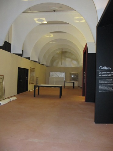
IMG_0472

Below: Conservator-artist-genius Eneko Fraile has been piecing together the 25 sheets of the massive Bohemia map of 1722. Such was the size and complexity of the job (each sheet was trimmed at some point 250 years ago, and perhaps unsurprisingly, not all of them match up) that the job had to be carried out in situ.
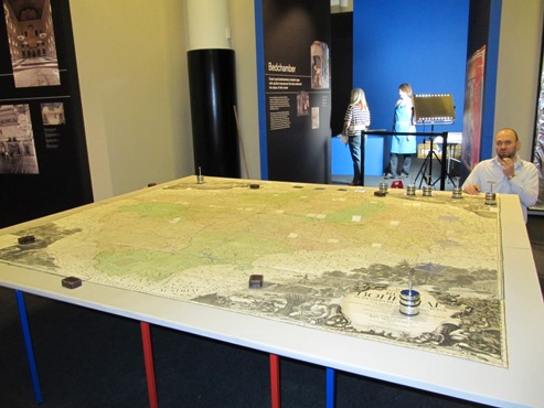
IMG_0497

Below: Colin contemplates the installation of the earliest surviving Chinese Globe (1623), a rather large, old and important ball of solid wood (the globe, not Colin).
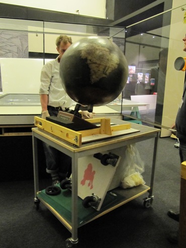
IMG_0502

Most excitingly of all, the loan items have been arriving in the gallery. Of which more later.